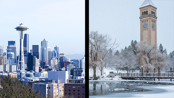
Washington State features one of the most dramatic climate contrasts in America, and honestly, it’s not what most people expect. While the rest of the country thinks “Washington” equals “rain,” the reality is far more complex. Experts consistently observe that this single state essentially contains two completely different worlds, separated by the mighty Cascade Range – climates in Western Washington vs. Eastern Washington.
And here’s why this matters more than you might think: Roughly 7.7 million people call Washington home, yet many residents don’t fully grasp just how radically different their neighbors’ weather experiences are just a few hours away. But, understanding these climate divisions is crucial for everything from crop selection to energy costs. Let’s put it this way: A farmer in Spokane and a Seattle office worker might as well live in different countries when it comes to weather planning.
“The sharp contrasts are the signature of our region,” University of Washington climatologist Cliff Mass told The Seattle Times’ Pacific NW Magazine.
The bottom line is that Washington’s climate story is really about mountains, moisture, and the Pacific Ocean creating two distinct environmental personalities.
The Great Cascades: Washington’s Climate Wall
The Cascade Mountains don’t just divide Washington geographically. They literally create weather. By acting like a massive atmospheric barrier, this mountain range essentially steals moisture from clouds before they can reach the eastern regions.
It works like this: Pacific storms roll inland, hit the western slopes of the Cascades, and dump their moisture as they’re forced upward. By the time these air masses descend on the eastern side, they’ve been wrung dry. This process is known as the “rain shadow effect,” and it dramatically transforms the state’s landscape.
Western Washington receives anywhere from 30 to 150 inches of precipitation annually, while eastern areas don’t often go beyond 10 inches. Take this example from the Washington State Climate Office: “Quinault, on the windward side of the Olympics, has an annual average precipitation of 151.45 inches but in Sequim, only 56 miles away as the crow flies and on the leeward side, the annual average precipitation is 23.98 inches.”
That’s not a small difference. That’s the difference between lush temperate rainforests and semi-arid steppes.
Western Washington: The Land of Liquid Sunshine
Let’s be honest about Western Washington’s reputation: It’s earned. But, the region’s wet season is more nuanced than most people realize.
The western climate operates on what locals call the “two-season system.” From roughly October through May, moisture dominates. Not necessarily the dramatic downpours that outsiders imagine, but rather a persistent, gentle precipitation known as drizzle. This is a type of rain that is slow and steady, with fairly uniform minute water droplets less than 0.5 mm (500 micrometers), and can last for days. Rain, as defined by NOAA, is “precipitation that falls to earth in drops more than 0.5 mm in diameter.”
Let’s take Seattle, for example. It averages 152 rainy days per year, but typically only sees five days with at least 1 inch of accumulating precipitation annually. Now, compare that to New York City, which averages 49.92 inches of rain per year over 122 days. So, the Big Apple has more rainfall but more dry days, whereas Seattle has less rainfall but spreads it out across more days.
Summer transforms the region completely. June through September typically brings a Mediterranean climate featuring dry, warm days with temperatures hovering in the comfortable 70s and 80s. This summer-dry, winter-wet pattern creates ideal conditions for the region’s famous coffee culture, wine production, and… well, that legendary moss growth.
Temperature
Temperature-wise, Western Washington stays remarkably moderate, thanks to the moderating effect of the Puget Sound and the Pacific Ocean, says the Washington State Climate Office. Of course, this excludes the Olympic Mountains and Cascade Mountains, which have a generally cooler temperature because of their higher altitude. Winters rarely dip below freezing for extended periods, while summers seldom become oppressively hot.
Eastern Washington: The Forgotten Desert
Here’s where things get interesting (and where most people’s assumptions fall apart completely). A large portion of Eastern Washington operates under what climatologists classify as a continental semi-arid climate, while other areas are basically high desert country.
The region experiences dramatic temperature swings that would shock Seattle residents. Summer temperatures average in the upper 80s to mid-90s (27 to 34 degrees Celsius), while winter can bring bone-chilling cold snaps well below zero.
What About Rain?
Precipitation patterns tell an even more dramatic story. Cities like Spokane average 15 to 30 inches (38 to 76 cm) annually, while some southeastern areas receive as little as 4 to 8 inches (around 10 to 20 cm). For context, that puts some portions of Eastern Washington in the same precipitation category as parts of Nevada and Arizona. In practical application, newcomers must bear in mind that successful farming here requires either irrigation systems or drought-resistant crops.
The wind factor adds another layer of complexity. Eastern Washington experiences persistent winds attributable to the region’s position between mountain ranges and its continental location. These winds create additional challenges and opportunities. Wind energy professionals have increasingly recognized the region’s potential for renewable energy generation.
Microclimates and Regional Variations: It Gets Complicated
Both sides of the state contain significant climate variations within their regions. Western Washington ranges from the temperate rainforests of the Olympic Peninsula (where annual precipitation can exceed 140 inches (around 356 cm)) to the relatively dry “rain shadow” areas around Sequim (which receives only an average of 10 to 15 inches (25 to 38 cm) annually).
Table 1. Western Washington’s Climate Divisions
| Climate Division | Description |
| West Olympic Coast | This is the rainforest area located along the southwestern and western slopes of the Olympic Mountains. |
| Northeast Olympic-San Juan | This belt in the rain shadow of the Olympic Mountains is the smallest climate division and the driest area in Western Washington. It encompasses the lower elevations along the northeastern slope of the Olympic Mountains extending eastward along the Strait of Juan de Fuca and then northward into the San Juan Islands. |
| Puget Sounds Lowlands | This region includes the lowlands nestled between the Olympics and the Cascades. Elevation breaches 1000, except the northeast side of the Olympic Mountains which have higher elevations up to between 4,000 and 5,000 ft. |
| East Olympic Cascade Foothills | This area encompasses the eastern slopes of the Olympic Mountains and the beginning of the western slopes of the Cascade Mountains, as well as parts of southwest WA. |
| Cascade Mountains West | The Cascade Mountains include rugged terrain, the tallest peak in WA (Mt. Rainier at 14,410 ft), and alpine glaciers. |
Source: Western Regional Climate Center (WRCC) and Washington State Climate Office
Eastern Washington similarly varies dramatically. The Palouse region experiences different patterns than the Columbia River valley, while the northeastern counties near the Canadian border operate under yet another climate regime.
Table 2. Eastern Washington’s Climate Divisions
| Climate Division | Description |
| East Slope Cascades | This area extends from the summit of the Cascades eastward for distances varying from 25 to 75 miles and from the Canadian Border to the Columbia River. |
| Okanogan Big Bend | This area includes fruit producing valleys along the Okanogan, Methow and Columbia Rivers, grazing land along the southern Okanogan highlands, the Waterville Plateau and part of the channeled scablands. The elevation varies from approximately 1,000 feet in the lower river valleys to 3,000 feet over the Waterville Plateau and Okanogan highlands. |
| Central Basin | This climate division encompasses the Lower Columbia Basin and is the lowest and driest division in eastern Washington. |
| Northeastern | This area encompasses the lower elevations of the Spokane River valley but mostly includes higher elevations of the Okanogan highlands (ranging from 2,000 to 6,000 ft). |
| Palouse Blue Mountains | This division encompasses the southeastern portion of the state from Spokane to the Oregon border and includes the Blue Mountains (elevation ~6,500 ft). |
Source: Western Regional Climate Center (WRCC) and Washington State Climate Office
Moreover, urban heat island effects further complicate the picture. Cities like Spokane and Seattle create their own microclimates that differ measurably from surrounding rural areas.


